Three numbers
The similarity trap. Ask for well 4902511080 and the log that actually carries that number scores 0.324, while an unrelated page of digits scores 0.729. That is not a bad embedding — a space that puts digits near digits is working as designed. It simply has no mechanism for which. Every identifier, quantity and group membership in the collection has this problem.
Looked up, not ranked. Recall@1 on well-number questions goes from 36% to 92% the moment an identifier in the question becomes a lookup against the index instead of a point in the vector space. No reranker, no larger model, no cleverer chunking — the retrieval stage simply stops being asked a question it cannot answer.
And it stays honest. Across 992 documents with nothing to do with wells: 139,629 bare 10/12/14-digit runs, of which 4,607 carry a plausible state and county and would pass on structure alone. Requiring a label before the digits leaves none of them. The label discriminates; the code table only confirms.
The finding
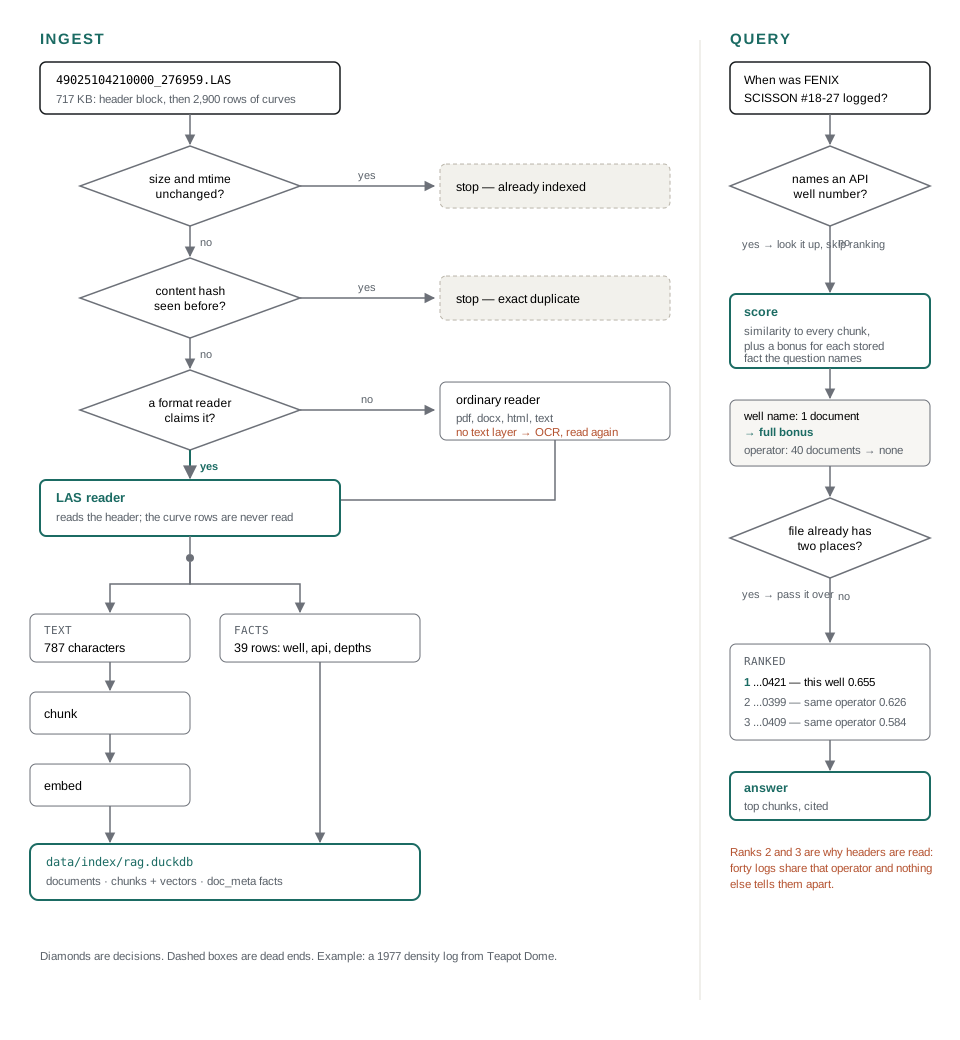
One result shaped everything else here: embeddings cannot locate identifiers, quantities, or group membership. Not “do it badly” — there is no mechanism. A well number, a seismic line name, a derived trace length, a coordinate system: each is a key, and a key is precisely what a similarity score cannot resolve. So each one got an exact lookup, and each lookup is measured below against the ranked baseline it replaced.
Around that sits a deliberately small pipeline: walk a folder, read what can be read, chunk
it, embed it, answer with citations. One DuckDB file holds the text, the vectors and the
extracted facts. Both models are fixed and cheap on purpose —
openai/text-embedding-3-small embeds and
inclusionai/ling-3.0-flash answers, through OpenRouter. Comparing models is not
the point of this.
26-SEP-1977, is
the DATE line on the left.
The readers
| format | what is indexed | what is not |
|---|---|---|
| LAS well logs | the header as a sentence, plus one fact per curve, depth range, well, field, operator | the log curves themselves |
| SEG-Y seismic | the EBCDIC textual header, decoded, plus sample rate and trace geometry | the traces |
| SEG-P1 positioning | header labels, line names, shotpoint range, point count | the coordinates |
| ESRI shapefile | title and abstract from .shp.xml, CRS from .prj, extent from .shp, and the .dbf attributes worth searching | the geometry |
Excel .xls | every column header, the values of the textual columns, and any well numbers | the values of numeric and date columns |
Seismic, measured
Without a reader, libmagic cannot name a SEG-Y file at all, so it is dropped with a recorded reason and nothing inside it is searchable. With one, the same 54 files yield 119 passages and 741 facts, every stored number checked against the range its field allows.
Ground truth comes from the headers themselves: a file whose card reads
CLIENT: LITHOPROBE belongs in the answer set for a question about Lithoprobe. A
seismic archive is many files per survey, so these questions have several right answers and
are scored against the set rather than one blessed document.
| question type | n | top hit, ranked | top hit, looked up |
|---|---|---|---|
| seismic line name | 8 | 0% | 100% |
| trace length | 11 | 0% | 100% |
| sample interval | 8 | 38% | 100% |
| samples per trace | 12 | 75% | 100% |
| whole set | 48 | — | 98% top hit, 99% recall@10 |
The zeroes are the interesting rows. Trace length is derived — sample interval times sample count — so the number appears nowhere in the file and nothing in the index resembles the question. Ranking has nothing to grip; a lookup answers it exactly. The unit has to appear in the question too, so “18000 barrels” is never read as a trace length. A sample interval is stored twice, in microseconds and milliseconds, so a question in either unit matches whichever way the file was written.
Sample counts are the weakest case for a lookup and still worth it: 2000 is real
text in the header, so ranking already found the right files most of the time — and put
the wrong one first a quarter of the time.
The claim, measured on well logs
Every reader here has a question set built the same mechanical way: each question comes from a value the index actually holds, and its answer set is every document holding that value. The one carrying this project's central claim was, until recently, the exception — its questions lived only in the general corpus set, 28 of them drafted by a model, which left the strongest claim in the repository resting on its softest evidence.
| 55 questions about well logs | n | top hit | recall@10 |
|---|---|---|---|
what is the API number for well FENIX & SCISSON "A" #108-29? | 12 | 92% | 100% |
which wells did WELEX log? | 3 | 100% | 100% |
which logs have a BULK DENSITY curve? | 8 | 75% | 82% |
which logs are from the TEAPOT DOME field? | 12 | 58% | 76% |
which logs were run for FENIX & SCISSON? | 8 | 50% | 80% |
which wells were logged in 1977? | 12 | 100% | 100% |
| all | 55 | 78% | 90% |
The first row is the claim. Name a well and the log that records it comes back first 83% of the time, and every log of that well comes back 100% of the time. That is the thing a similarity score could not do at all.
The last row is the same lesson arriving again, and refused this time. A year names a set of documents the way a state does — 1977 is on 169 of 1,632 — so the rarity bonus spreads evenly across all of them and tells them apart not at all. Filtering is what this pipeline does everywhere else that shape appears, and making the year a filter does take these questions from 0% to 100%. It is not done, because projection names contain years: "which shapefiles are in NAD 1983 HARN StatePlane Colorado North" would then match the year 1983 as well, the two filters are combined, and the group set falls from 53% to 21% while the hand-written question set loses 0.046 of its MRR. One question type is left failing rather than bought at that price.
Company names are asked by their root and answered by containment, because
FENIX & SCISSON is written 23 ways across 461 documents —
FENIX & SCISSON INC, FENIX AND SCISSON,
FENIX & SCISSION, and once FENIX $ SCISSON. That is not the
name normalisation this project declines to do; it is what the question means.
A year is a year only when something happened in it
Those year questions scored 0% until recently, and the reason is the same lesson as coordinate systems arriving a third time. 1977 is on 169 of 1,632 documents, so the rarity bonus spreads evenly across all of them and tells them apart not at all. Group membership needs a filter.
Making the year a filter, on its own, was measured and refused: the group questions fell from 53% to 21% and the hand-written set lost 0.046 of its MRR, because projection names carry years. Two smaller rules made it safe, and both are general rather than special cases for dates.
A match that another match already contains is dropped. "Which shapefiles are in NAD 1983 HARN StatePlane Colorado North" names one thing, and the index answered with four: the projection, a log year of 1983, a state of Colorado, and a column named FIPS. Each became its own filter, they combined, and nothing survived. The longer match explains more of the question and already accounts for the shorter ones.
And four digits are a date only when the question says something was done in them. That is the rule API numbers have always had, for the same reason: a bare number is not evidence, a labelled one is. "Logged in 1977" keeps its year; "the 2012 update readme" does not — and that second one is a real question from the hand-written set, which a bare year filter broke.
Every question set improved or held: well logs 49% to 78% on the top hit, the corpus MRR 0.657 to 0.678, spreadsheets 57% to 61%, map layers 67% to 69%, and the group and seismic sets unchanged.
Well numbers have no canonical length
Vendors write fourteen digits. State agencies write ten. A map layer sometimes writes seven, with the state code left off entirely. Each is what that system holds, and picking one as “correct” throws away the sidetrack and completion codes the longer forms carry. So no length is imposed: separators are stripped, the digits are kept as written, and two numbers name the same well when one runs on from the other — sharing a start, where both begin at the state, or an end, where one has dropped it.
A fragment can be starred like a glob, in a question or in --where:
| pattern | matches |
|---|---|
*2506325 | ends with |
2506325* | starts with |
*2506325* | holds it anywhere |
The last matters more than it looks. A fourteen-digit number carries a sidetrack
after the well, so a fragment lifted out of a map layer lands in the middle of it:
2506325 ends 2506325 and sits inside 490250632500.
Only the double star reaches both.
A label in prose, a column in a table
API numbers are detected in any document — a completion report, a loader log, a scanned
permit — and validated against this project's own table of state and county codes. In
prose a label must precede the digits, which is what produced the zero in the third card
above. In a .dbf column no label is required, and that asymmetry is the point:
a column is evidence, a sentence isn't. If most of a column validates, it is
a column of well numbers whatever it happens to be called. In this corpus GeoGraphix layers
keep them under DataId and WellID; across every other numeric
column — TypeId, ObjectID, ParentCode,
ASR_ID — not one value validates. That found 6,908 well numbers
across four layers, none of them searchable before.
The state and county are already in the digits
The numbering puts two digits of state and three of county at the front, so a stored well number already says where it is. Until that is read back out, nobody can search for it by name: “what LAS files are in TX” previously matched nothing whatsoever and returned Wyoming logs.
Only 12- and 14-digit values are trusted for it. Ten is excluded because the
last ten digits of 490250632500 are 0250632500, which parses as
state 02, county 506 — a real-looking Arizona well that does not exist. Shorter values
are fragments whose digits do not line up at all: Teapot_Wells writes
2500153, which is county 025 and well 00153 with the state gone. A wrong county
is worse than no county. Across the corpus this reads WY and
Natrona off the two layers storing twelve digits, and correctly nothing off the
two storing seven.
A two-letter code is only recognised written in capitals, because half of them are ordinary
words — IN, OR, ME, OK,
HI, DE, LA. “Wells in or near the
field” would otherwise ask for Indiana and Oregon.
Shapefiles: classify the columns by measurement
.dbf attributes are sorted by what their values do, never by what they
are named, because field names are a vendor's abbreviations and there is no list to check
them against. Values that repeat are a category and become a filterable fact; values nearly
all distinct name individual things and go into the text; a column that is 90% one value
describes the layer rather than the row; a column of bare digits is dropped, because
retrieval is text and a number that names nothing cannot be searched for.
Group membership is filtered, not ranked
A projection, a state and a county each name a set of documents rather than describing one, and the rarity boost cannot deliver them: 21 layers out of 2,520 documents earn about 0.06, which will not lift anything past 71,000 chunks. An exact match narrows the candidates instead.
| 19 questions naming a projection, datum, state or county | top hit right | recall@10 |
|---|---|---|
| ranked | 21% | 29% |
| filtered | 53% | 47% |
Read that as filtering is how these get answered at all, not as a score. Ground truth here is the documents carrying the value, which is close to what the filter selects, so the filtered arm is partly measuring itself. The ranked arm is the honest half: without a filter these questions mostly go unanswered. What shows the filter costs nothing is that every other set on this page is unchanged by it. Nineteen questions is a small set: the ranked arm has read 16%, 21% and 26% on different runs of the same questions, which is one or two of them moving and well inside the ±20 points that many questions buy. The figure above is one run, not a constant.
Whether silence is a contradiction is read from the index
The obvious way to filter — drop every document that does not carry the key —
deleted every road and benchmark layer for any question naming a state, and cost the
shapefile set seven points. Only a document with a parsed well number carries
api_state; a roads layer saying nothing about a state is not claiming to be
outside it. So the rule is asked of the data rather than written down:
| key | coverage | so a document that is silent… |
|---|---|---|
api_state | 96% of LAS files | …is a log with no API number — rare, so treated as a mismatch. A log that says WY is out when the question says TX. |
crs_name | 66% of shapefiles | …is one of the third with no usable .prj — kept, because it never raised the subject. |
My own assumption going in was that every shapefile has a .prj. A third of them
do not. No list of keys is maintained for this, so a new reader that always records something
gets the same treatment with no edit.
The questions people actually ask
The shapefile set asks the three things a person really puts to a pile of map layers, and scores 69% on the top hit, 82% recall@10 over 107 of them:
| question | n | top hit right | recall@10 |
|---|---|---|---|
| do I have spatial data for X? | 67 | 64% | 87% |
| which shapefile has Y? | 20 | 55% | 70% |
| which layer holds well 490250632500? | 10 | 100% | 60% |
which layer holds *2506325? | 10 | 100% | 100% |
Every well-number question puts a right answer first. Only the starred form recovers the whole answer set, which is exactly what the wildcards are for. An earlier version of this set asked “which layer has 53 features?”, scored 0%, and was measuring the question generator rather than the system — nobody searches for an exact feature count. Asked the realistic way, “how many features does Teapot_Wells have”, it returns rank one.
Spreadsheets, read more strictly than a map layer
A spreadsheet is an attribute table that happens to be in a file format, so its columns go
through the same four measurements as a .dbf. Reading is
python-calamine, a Rust parser with no Python dependencies and no system
libraries — 2 MB on disk against roughly 400 MB of LibreOffice and a subprocess per
file. It opens 68 of the 72 .xls files here. Three more are Excel 4.0, which
wrote raw BIFF with no OLE container, and xlrd still reads those. The 72nd is
password protected and is skipped with that as its reason.
Then one rule a .dbf does not get: a numeric or date column contributes
its header and nothing else. No values in the text, no range in the facts. An
attribute table is mostly names; a spreadsheet is mostly arithmetic, and nobody searches for
a reading. The header still counts, because Total Depth or Oil BBLS
says what a sheet is about even when no number in it is searchable. The exception is the
identifier: API numbers are read out of any column, numeric or not, and filed as facts.
Two lab workbooks in the corpus made the case — 4,611 and 2,076 rows of microarray readings producing 8,100 of the 10,300 spreadsheet chunks, none of them answerable by any question. But the rule alone barely touched the larger one, and the reason is the useful part: it has a two-row header. A header row was required to be entirely filled, real ones leave spacer columns blank, so the sheet was read as headerless and its stranded label row sat inside every data column — which made 4,610 measurements look like prose. Loosening that to most of the row is what actually worked.
| 69 readable workbooks | segments | text | cost to embed |
|---|---|---|---|
| rows as prose | 8,203 | 9.1 MB | $0.046 |
| text columns only | 3,027 | 3.0 MB | $0.015 |
And a set of its own, 138 questions, built the same mechanical way: 61% on the top hit, 81% recall@10. Two of its rows say more than the total.
| 138 questions about spreadsheets | n | top hit | recall@10 |
|---|---|---|---|
which file has a column called Unit or Lease Name? | 66 | 56% | 89% |
which file lists SALT CREEK? | 24 | 67% | 86% |
which spreadsheet lists SALT CREEK? | 24 | 79% | 86% |
which spreadsheet has well 2506988? | 12 | 0% | 0% |
which spreadsheet has well *2506988*? | 12 | 100% | 100% |
Rows two and three are the same 24 values, asked twice. Adding the word
"spreadsheet" is worth 12 points, because a workbook's summary chunk opens
Spreadsheet WY_wellsT39_R78.xls: 1 sheet and a map layer's opens
Map layer (shapefile). A document that says what it is can be asked for by what
it is. I had claimed the opposite before measuring it.
Rows four and five are one boundary seen from both sides. A workbook writes its well numbers seven digits long with the state code dropped, and a bare number that short is not treated as an identifier at all — at that length it could be anything. Starred, declaring it a fragment, it is exact. The column questions are what the numeric rule pays for: a sheet gives up the header of every numeric column and none of its values, and those headers are findable.
Facts and well numbers are untouched at 4,671 rows and 967 wells. Mixed columns stay, which
is the visible cost: Elevation is 700 numbers and 267 strings like
5063 GR where the text carries the datum, so it is not purely numeric and its
rows still read Elevation: 0 where the number stands alone.
Being a thing, versus listing it
Indexing those 69 workbooks cost the corpus three points of recall@5, and the cause was not noise — it was a hole in the scoring that the spreadsheets happened to walk through.
Asked “when was NPR 3 #51-41SX10UP4 logged?”, the log that records that
well scores 0.4494 and takes the full rarity bonus, because it holds a well
value no other document has. A spreadsheet of 967 Teapot wells scores 0.4972 and takes
the same full bonus, because its own Lease Number column happens to
hold a value that is also unique in the corpus. Nothing separated the question named
this document's well from the question named something this document happens to
contain.
Inverse document frequency is only half of the usual pair. The other half is the document
side: the log holds one well and is that well; the
spreadsheet holds 71 lease number values and lists
one. That count is already in the index, so the measure needs no list of keys that count as
identifiers.
Applied absolutely, it overcorrected badly — and the failure is more instructive than the fix. Holding many values is exactly what makes a document right for “which shapefile has Mulberry Street?”, and that question set fell from 45% to 5% on the top hit. Identity and mention are not properties of a document at all; they are properties of the comparison.
So each match is weighed against the most singular match the question actually found. When something claims the value as its identity, mentions rank below it; when every candidate is a list, nobody is penalised. Measured against the index before spreadsheets existed:
| eval set | no spreadsheets | spreadsheets, no fix | spreadsheets + fix |
|---|---|---|---|
| corpus, recall@5 | 77% | 74% | 77% |
| subset, recall@5 | 77% | 73% | 82% |
| shapefile, top hit | 67% | 67% | 67% |
| group, top hit | 47% | 47% | 53% |
| SEG-Y, top hit | 98% | 98% | 98% |
So 69 spreadsheets and 3,094 chunks are indexed at no cost to recall@5, and two sets come out ahead of where they were before. None of this touches identifier or group questions: API and UWI numbers are looked up, and a projection, state or county filters — which is why the well-number sets sat at 100% throughout.
Retrieval, overall
Cosine similarity, with three corrections that matter for a collection like this one: an
identifier in the question is looked up rather than ranked; metadata the question names lifts
the documents carrying it, weighted by rarity, so a well name held by one document outweighs
state=WYOMING held by 1,375; and no single document may take more than its share
of the answer — a map layer of 2,111 wells is 500 chunks that read alike, and without
that cap it held every place in the top ten for any question about wells.
| format | n | recall@1 | recall@5 | MRR |
|---|---|---|---|---|
| LAS | 28 | 93% | 93% | 0.929 |
| 22 | 50% | 77% | 0.636 | |
| plain text | 22 | 50% | 59% | 0.552 |
| HTML | 18 | 44% | 72% | 0.574 |
| shapefile | 10 | 50% | 80% | 0.603 |
| all | 103 | 60% | 77% | 0.678 |
Read recall@5 first — top_k is 6, so that is what the model actually sees.
The LAS row is what a format reader buys you. The plain-text and HTML rows are ordinary
documents with no reader and no metadata, and they are the honest floor this sits on.
Sample size is why this set exists at all. At 22 questions the 95% interval on a recall figure is about ±16 points, so any change worth less than that was indistinguishable from luck. At 103 it is about ±8 — still wide enough to be careful with, and stated here rather than hidden. The whole corpus rebuilds cold in about five and a half minutes for $0.57: 2,599 files, 71,013 chunks, 71,612 extracted facts. No question in this set has a spreadsheet as its answer — the set predates that reader — so the 3,094 spreadsheet chunks appear here only as competition, which is what the next section is about.
Two things built, measured, and switched off
Both are in the repository, both are wired up, and both default to off with the numbers written next to the setting. Deleting them would hide the result.
BM25 and hybrid search
DuckDB's FTS extension, fused with the dense ranking by reciprocal rank. On 39 seismic questions with the lookups disabled it halved retrieval — 36% to 18% on the top hit — and cost recall with them enabled. Asked “where is seismic line 93D” it returns a telephone-system procurement PDF, because “line” appears in 1,121 chunks and the one discriminating token appears in 138.
HNSW vector index
DuckDB's VSS extension, built at ingest over all 71,013 vectors in about six seconds. The planner only reaches an HNSW index through a bare nearest-neighbour query, which means candidates are cut before the filter and the metadata boost are applied — and those are precisely the two things this pipeline needs exact. Merging every chunk of a boosted document back in recovered most of the loss and not all of it:
| measured before the spreadsheets were added | recall@5 | MRR | SQL time |
|---|---|---|---|
| exact scan | 78% | 0.668 | 0.40s |
| HNSW index | 73% | 0.637 | 0.09s |
It saves 0.3 seconds of SQL in a query that spends most of a second waiting on the embedding API. At this many vectors the brute-force scan is the better trade. At ten million it would not be, and the switch is already there.
What this does not do, and why
No reranker
“This is just a demo for small models.”
A cross-encoder reranker is close to table stakes in production RAG, and its absence here is deliberate rather than overlooked. The entire premise is a cheap, fixed model pair; adding a reranking pass would change what is being demonstrated.
Some eval questions were drafted by a model
“Yes, the LLM helped write some questions, but with a lot of guidance.”
Stated plainly, because burying it would be worse. Each generated question came from a chunk the index actually holds and had to survive four mechanical gates; the LAS and SEG-Y questions were templated from header fields instead, because a model reading one LAS header writes the same question every time. The real defence is the 22 hand-written questions, which track the 103 generated ones closely — 55% / 82% / MRR 0.668 against 60% / 77% / MRR 0.678, with the hand-written set still scoring higher on recall@5. If the generated set were self-flattering, that would not happen.
Hard-coded key lists
“Those are often part of the format spec — valid for LAS, probably no other format here.”
A short list of well and projection keys looks like special-casing to pass an eval. Where a published standard names the key, it is not — deriving it at runtime would be inventing flexibility the format does not have. Checking that claim key by key gives three tiers, not two:
| keys | where they come from | hard-coding them is |
|---|---|---|
WELL, API, UWI, FLD, CNTY, STAT, COMP, SRVC, DATE, STRT/STOP | the CWLS LAS 2.0 specification names every one | correct |
| sample interval, samples per trace, sample format | SEG-Y fixes them at byte offsets 3217, 3221 and 3225 of the binary header | correct |
PROJCS, GEOGCS, DATUM | OGC Well-Known Text keywords | correct |
| state and county digits | the API well-number structure: 2, then 3, then 5 | correct |
CLIENT, AREA, LINE, SURVEY… | nothing — SEG-Y's 3,200-byte text card is free-form, and these labels are convention | a guess |
.dbf columns, spreadsheet headers | nothing — vendor abbreviations with no list to check against | a guess |
So the instinct behind the objection is right, and the tell is visible in the reader
itself: the SEG-Y text-card handler carries synonym lists —
CLIENT, COMPANY and PROCESSED FOR all mean the same
thing — precisely because no standard says which one a processor will write. The two
rows at the bottom are the ones that had to be measured instead: the column
classification, the silence rule, and the subsumption rule above are all read from the index
rather than listed here.
Retrieval is evaluated; groundedness is not
“This is just a demo — if your E&P data is crap, it can't help you.”
Every number on this page measures retrieval: recall@k and MRR against known answers, with no model judging the output. Nothing verifies that the generated answer is faithful to the passages it cites. That is a real gap, named rather than papered over — but the prior failure in this domain is not an ungrounded sentence, it is a data room where the right file was never findable in the first place.
Where it stops
Two gaps are left open deliberately. Neither is exotic, and both are the kind of thing that turns a demonstration into something an asset team would actually run:
- Legacy word processing and slides are still unreadable. 81
.docand 59.pptfiles in this corpus are skipped with a recorded reason — and in a real data room that stratum is where the partnership agreements, the AFEs and the decades of internal memos live.textutilcovers.docon macOS and headless LibreOffice covers both; neither is wired in, so the pipeline reports the gap instead of quietly pretending the corpus was complete..xlsused to be on this list and is not any more: 69 of 73 workbooks are read bypython-calamine, a 2 MB Rust parser with no system libraries, which is the argument for closing the other two the same way rather than shelling out to an office suite. - Company names are only half-normalised. A name is tidied as far as its trailing legal suffix, and no further, because ENCANA appeared as three spellings across five files and split every answer set on its own. Real normalisation — ampersands against “and”, abbreviations, subsidiaries, former names, the whole merger history of an operator — is a substantially larger job with its own authority file, and pretending a regex covers it would be worse than saying it does not. Every operator-based answer on this page carries that caveat.
The pattern in both is the same one the rest of the project argues for: a gap that is named and measured is worth more than a gap that is papered over, because the first one tells you what to buy next and the second one tells you nothing.
Untrusted text in the prompt
Retrieved chunks come from files nobody vetted, and they go into a prompt. Each source is fenced with a random token generated per request, and that token is stripped from the source text before it is inserted — so a document cannot close the fence and start addressing the model as the operator.
Running it
uv run geo-mini-rag ingest             # read data/raw, embed via OpenRouter
uv run geo-mini-rag stats              # what got indexed, and why the rest did not
uv run geo-mini-rag search "question"  # retrieval only, one tiny embedding call
uv run geo-mini-rag ask "question"     # answer with citations
To see what the pipeline reads out of a single file, with no API key and no database:
python -m geo_mini_rag.ep.inspect data/raw/las/some.las
python -m geo_mini_rag.ep.inspect --facts data/raw/gis/layer.shp